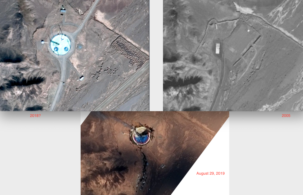
The US was not involved in the “catastrophic accident” that befell an Iranian rocket launch, US President Donald Trump tweeted on Friday. The tweet adds mystery to what exactly happened in Iran. Satellite images had already disclosed that an Iranian rocket had exploded on Thursday.
The imagery was provided to news companies, including NPR, and was from a commercial company. “This failure happened maybe a couple minutes before the image was taken,” Dave Schmerler, a senior research associate at the Middlebury Institute, told NPR. The US had warned Iran about this type of activity. The rocket might have been part of Iran’s space program to carry a satellite, but it could also be part of Iran’s rocket and missile program.
A US official told Reuters that Iran had suffered a satellite launch failure. “It was due to some technical issues and it exploded but our young scientists are working to fix the problem, an Iranian official said.
Trump’s tweet adds a layer of mystery to what happened because even though it denies involvement, the very fact he tweeted about it appears to reveal US interest in the explosion. Trump’s tweet is unusually technical, noting it was a Safir SLV Launch at Semnan Launch Site One. “I wish Iran best wishes and good luck in determining what happened at Site One.” Iranian media had not commented on the failure by Friday evening.
The Safir rocket was first launched in 2009 and carried a satellite into orbit. The US has been upping sanctions on Iran as part of its maximum pressure campaign. A US cyber attack allegedly harmed Iran’s ability to target tankers recently. Trump’s tweet comes in that context. It included a photo that appears to be a photo of a photo. The photo shows the destroyed rocket and damaged tower. It also shows damaged vehicles and a damaged Safir launcher that was attached to a mobile erector, one that could be driven to the site. It seems the photo was produced from a different image than the satellite, and has more detail, and it appears that Trump or someone on his team took a photo of the image which had been mocked up with the labels showing the launcher and debris. This may have been part of a briefing provided the President.
Internet “intel” accounts that like to use open source information to investigate incidents had spent all Thursday night and Friday looking at details of the satellite image. The Twitter account AuroraIntel notes that the failed launch at the Imam Khomeini Space port was shown on a satellite image taken at 11:18 in the morning (06:48 UTC).
The explosion took place in Semnan province. Up until Trump’s tweet it was thought that the satellite might have spotted this through good luck or “sharp eyes.” It now appears to be something more.
Trump’s tweet stirred controversy online because some suggested that the image might be classified or revealed intelligence that US intelligence agencies might not want out in public.
For instance:
And
Or
Some suggested it wasn’t from a satellite, which led some to suggest it was from a photo taken inside Iran. Many, many people had quick takes on this.
But it turned out it wasn’t “top secret.”
A US defense official told CNBC that the image “appeared to be a snapshot of a physical copy of the satellite image” and that it was included in the Friday intelligence briefing. The image had already been mocked up to indicate different elements in the frame. In addition a map of Iran and a “north” arrow had been added. This was therefore not a raw intelligence image, it was one that had been prepared for the President or his team of advisors and officials.
Nevertheless questions remained about the level of detail in the image and why it differed from an earlier satellite image. Elements of Trump’s tweet suggest that it was not his normal tone and that the information was provided directly as the tweet was constructed, such as details about the “Safir SLV Launch at Semnan Launch Site One.”

Previously information on the Semnan site had called it the Imam Khomeini Space Center in Iran’s Semnan province. The Nahid 1 satellite, which is alleged to be a telecommunications satellite by Iran, was supposed to launched to an orbit of 250km from Earth. It is not clear if the satellite itself survived the destruction. What is interesting is that details about the Semnan site appear in a book called Emerging Space Powers by Brian Harvey, Henk Smid and Theo Pirard and published in 2010. At the time the site was less developed but it still contained command and control as well as trucks and a “transporter-erector” as well as four lightning tours with flood lights. A Google image from earlier this year or a previous year showed the site had been painted and there was Farsi written on the launch pad area.

The Trump image is a bit different, it shows that the pad has been painted again. A slogan meaning “national power” appears along one side of the launch area. It is so large that it is obviously intended to be seen from above, probably by satellites.
Some people online are trying to figure out how the image was taken,


2 comments
It’s interesting to discuss how the photo’s came about. It makes for good spy fiction. But what really matters most is that Iran had a break-down. That’s all that’s important. Stopped in their tracks till next time. And of course, there will be a next time.
This happened in 2019! Why is it taking up space here in 2021? Just click bait. CD Media, you have lost me as a reader and subscriber!